In the Studio Layout Manager, you can create new layouts (templates) and view and edit existing layouts. These layouts can be combined into packages. A package allows a single print operation to be performed on all layouts in the package. Each layout can have associated data fields. These fields can be manually entered for every print job and they will show on the map printout. For ease of use and time savings, a Save and Load feature has been added for field presets.
Packages
A package is a grouping of one or more layouts. By combining layouts into a package, a single print operation can be applied to multiple layouts.
At least one layout should exist prior to creating a package.
To create a package:
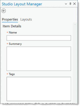
1.In Studio Layout Manager > Packages tab, click Create.
2.In the Properties tab, fill in the following mandatory fields:

a.Name
b.Summary
c.Tags
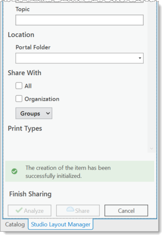
3.Fill in the remainder of the form.

4.Optional fields include:
a.Topic
b.Location
5.Choose a Share With option.
6.Click Analyze to check for errors.
7.If no errors are present, click Share.
Layouts
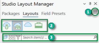
Layouts shows all your layouts (templates) based on your account, logged in portal, or current project. It allows for searching, categorizing, filtering, and editing of your layouts.

1.Hamburger Menu
2.Content Selector
a.My Content ![]() - This shows the layouts associated with your account.
- This shows the layouts associated with your account.
b.My Organization ![]() - This shows all layouts on your organization's portal, not including the workflows associated with your account.
- This shows all layouts on your organization's portal, not including the workflows associated with your account.
c.All Workflows ![]() - This shows all layouts on your organization's portal.
- This shows all layouts on your organization's portal.
d.Project ![]() - This shows all layouts associated with the current project.
- This shows all layouts associated with the current project.
3.Filter Section
a.Collapse Group - Collapse all item groupings.
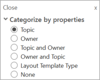
b.Categorize - This sorts the Layout List using properties of the layouts.

c.Filter - Enter a term here to find related layouts. The search term could be any associated names, titles, summaries, topics, or tags.
d.Search - Enter any search term here. The search is performed on layout names, topics, tags, type, and owners.
Field Presets
When a map is printed, a set of fields can be included. These fields could be data directly taken from the geodatabase or they can be manually entered. To save time, field presets allow you to save data fields and load them later at the time of printing.
The Field Presets tab shows all your field presets based on your account, logged in portal, or current project. It allows for creating, searching, categorizing, filtering, and editing of your field presets.