Coordinates Module
This module can be configured using Manager. See Map Widgets for instructions.
The Coordinates Module displays the map coordinates of the current position of the mouse pointer. Users may select from a variety of coordinate systems and formats. The map coordinates may be opened or closed.
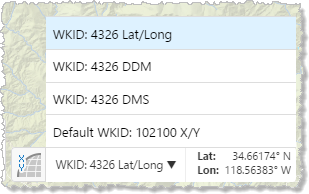
Map coordinates with the coordinate system menu open
The Map Coordinates map widget is only available for the Desktop interface.
Configuration Properties
Module
No configuration properties
Views
-
CoordinatesView: Noconfigurationproperties
View Models
-
CoordinatesViewModel:-
isEnabled: To enable the coordinates feature, set totrue. The default istrue. -
openByDefault: To open the coordinates when the viewer starts, set totrue. The default isfalse. -
coordinatesModel: Sets the coordinates view model. The default value isMapCoordinatesModel, which is a view model configured as part of the Map Module. -
useBasemapCoordinates: To include the basemap's coordinate system, set totrue. The default istrue. -
numDigits: The number of decimal places to use for coordinates. The default is5. -
coordinateSystems: An array of coordinate systems. Coordinate systems have the following properties:-
displayName: The name to display for this coordinate system. -
wkid: The well-known ID of the coordinate system. This property overrides thewktproperty.For a list of WKIDs, see Esri's Geographic Coordinate Systems or Projected Coordinate Systems documentation.
-
wkt: The well-known text of the coordinate system. This property is overridden by thewkidproperty.For a list of WKTs, see Esri's Geographic Coordinate Systems or Projected Coordinate Systems documentation.
-
output: The units to use for the coordinates. Possible values include:-
dms: Degrees, Minutes, Seconds -
ddm: Degrees, Decimal Minutes -
latLon: Latitude, Longitude -
xy: X, Y (in the units of the coordinate system)
-
-
-