Time Sliders
The Essentials Time Sliders feature is only available for ArcGIS Server feature layers that have time enabled.
ArcGIS Server time-aware layers store information about how the layer's dataset changes over time. Geocortex Essentials supports time-aware layers.
You can configure a time slider that end users use to visualize time-aware data in the viewer. The time slider shows and hides features based on each feature's time data and the user's time selection on the timeline.
Time-aware layers have a time extent. The time of each data point lies within its layer's time extent. The map also has a time extent, which is the full time extent of all the connected time-aware map services and layers.
Time Extent of a Map Service
The time extent of a map service with multiple time-aware layers spans the individual time extents of the layers. This is illustrated in the following figure. The top three horizontal lines represent the time extents of the map service's three time-aware layers. The bottom horizontal line is the time extent of the map service.
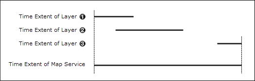
Time extent of a map service spans the time extents of its time-aware layers
For example, suppose your site has a map service with two time-aware layers:
-
Hurricanes Layer: Has data on hurricanes from March 12, 1950, to September 22, 2005.
-
Tsunamis Layer: Has data on tsunamis from July 16, 1995, to February 3, 2011.
The map service's time extent is March 12, 1950, to February 3, 2011.
You can override a map service's time extent.
Time Extent of the Map
The time extent of a site's map is determined similarly to how the time extent of a map service is determined, except in this case, it is the time extents of map services that are combined, instead of layers. The time extent of a site's map spans the time extents of all its time-aware map services.
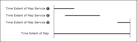
The time extent of a map spans the time extents of its time-aware map services
Configure Time Sliders
In Manager, you can configure new time sliders from the Time Sliders page. You can use the Add Time Slider button to create a new time slider configuration that users can choose in the viewer.
Alternatively, you can click the Import Time Sliders icon ![]() to add a time slider that is configured based on the map's current time-aware layers. The time slider's name and extent are generated from the layer information. If your map has multiple time-aware map services enabled, you can also create a preconfigured Aggregated Time Slider, which has a start time and end time that encompasses all of the map's time-aware layers.
to add a time slider that is configured based on the map's current time-aware layers. The time slider's name and extent are generated from the layer information. If your map has multiple time-aware map services enabled, you can also create a preconfigured Aggregated Time Slider, which has a start time and end time that encompasses all of the map's time-aware layers.
Once you have configured time sliders in Manager, you must
Time Slider Settings
Time sliders have the following settings:
-
Display Name: The display name. End users see this name in the viewer as the Time Profile when multiple time sliders are available.
-
Description: A description of the time slider. End users see this description in the viewer.
-
Slider Minimum: The earliest point for the period of time represented by the time slider.
-
Slider Maximum: The latest point for the period of time represented by the time slider.
-
Extent Minimum: The configured starting point of the time extent on the time slider.
For example, while the Slider Minimum for a time slider may be set to 9:00 AM, the Extent Minimum could be set to 11:00 AM.
-
Extent Maximum: The configured end point of the time extent on the time slider.
For example, while the Slider Maximum for a time slider may be set to 11:59 PM, the Extent Maximum could be set to 9:00 PM.
-
Date Format: The date and time format that the time slider displays in the viewer.
For more information about date/time formats, see Field Formatting.
-
Mode: Configures the time slider time mode. The mode can be configured to the following settings:
-
Time Extent: Displays a range of time that can manipulated. The range is defined by two draggable handles which mark the beginning and end of the time extent.
-
Cumulative From Start: Displays cumulative data over a time span. The slider's handle can be dragged to set the end of a time span. Unlike the Extent mode, there is no handle to set the beginning of the time span. The end user uses the handle to show more or less data as it accumulates over time.
-
Time Instant: Displays a particular instant in time. If the time-aware layer does not have data for that particular instant in time, the map renders no data.
-
-
Time Interval: Specifies how many time interval units should be between each selectable position on the timeline.
For example, a time-aware layer has 12 months of changes and the Time Interval Unit is set to months. If the Time Interval is set to 1, then the timeline has twelve unique positions.
-
Time Interval Unit: The unit of time that the timeline should display.
Each tick on a timeline represents an instant, as defined by the Time Interval and Time Interval Unit settings. The timeline shows a maximum of 50 instants. For example, even if the time interval is set to milliseconds and the time extent is set to 3 months, the timeline limits the selectable instants to 50. We recommend setting time intervals so that there are fewer than 50 instants on the timeline.
-
Snapping: Select whether the time slider should snap to the configured time interval or ignore the configure time interval.
Time Options
You can configure the mode in which the time slider works.
You can override a time-aware map service's time extent in Essentials. For example, if a map service provides 100 years of data, from January 1, 1900, to January 1, 2000, you can limit the data available in the viewer to be a portion of the 100 years of data. In this case, you could override the map service's time extent to start at January 1, 1980.
To configure a time-aware map service's time extent:
-
In
-
Click the Functional tab.
-
Select one of the following options from the Time Aware Mode menu, which is only available for OGC time-aware services:
-
Range: Requests the start and end times of the current time extent. This is the option selected by default.
-
Instant: Requests only a single time value - the end of the current time extent.
-
Default: Does not request a time value. Use with a time-aware service that has been configured to return data from a 'default' time when no time is specified. For example, a radar map service may return the latest available data if Default is selected.
Not every OGC time-aware service supports every Time Aware Mode.
-
-
Select the Override Time Settings checkbox.
If the Functional tab does not have settings for Override Time Settings, Start Time, and End Time, then the map service you are editing does not support time-aware layers.
-
Click in the Start Time box to open a calendar, and then click the date you want to use as the beginning of the time slider's time extent.
The date must be in UTC (Coordinated Universal Time).
-
Click in the End Time box to open a calendar, and then click the date you want to use as the end of the time slider's time extent.
The date must be in UTC (Coordinated Universal Time).
-
Click Apply Details.