Geolocation
Geolocation is the ability of a Mobile app to use the built-in location system on your device to find and show that device on a map. Of course, Location Services - must be turned on for this feature to work.
Geolocation not only identifies where your device is on the map, it also follows your device as you move. Geolocation can also show you which direction your device is pointing in relation to the map, which is useful if you have rotated the map and are not sure of the direction you are facing.
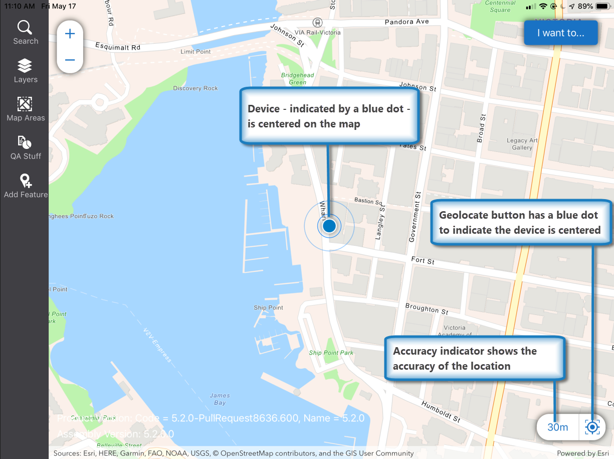
When a map opens on a device and the location services are on, the app uses the device location services to place the device within the visible map area. If the device is found in that area, it is displayed on the map with a marker - a blue dot:

The blue halo around the device marker indicates the accuracy of the device location, which is also indicated by the accuracy indicator beside the geolocate button in the bottom right corner:

If your app is enabled for high-precision GPS, you can also click the accuracy indicator to open the dialog where you apply settings for the GNSS receiver you plan to use.
If the device cannot determine its location, the geolocate button is shown as gray and crossed out:
![]()
When a device is able to determine its location, the geolocate button changes to blue:
![]()
To locate where you are on the map:
-
Open the Mobile app on the device and wait until the geolocation button turns blue.
If you see the blue dot, it indicates that your device has located you on the map.
-
Tap the geolocate button.

The map pans and zooms to center you on the map. This is important on a small device where only a small amount of the map is visible.
The geolocate button in the lower right corner, now has a blue dot in the middle to indicate it is in centered mode.
Centered Mode Tracking:
If you begin moving, on iOS and Android devices the marker on the map changes to an arrow that indicates your direction on the map:

While you are in centered mode, as you move, the device arrow tracks your position to the edge of the visible map and then automatically centers the device marker again to keep it visible.Flashlight Mode Tracking:
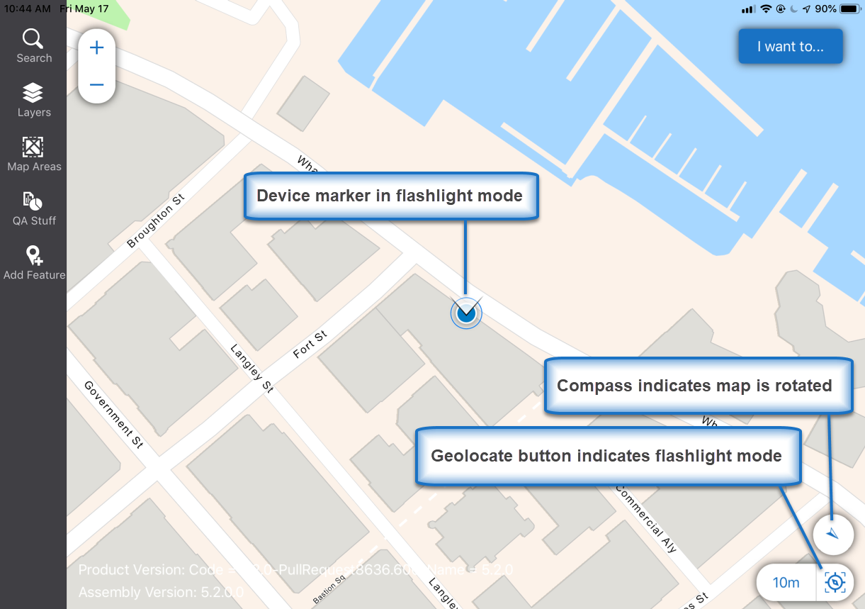
If you click the geolocate button again, the device marker changes to flashlight mode:

While you are in flashlight mode, as you move, the flashlight remains in the center of the map, which pans automatically and continuously to keep the device centered on the visible map.
The 'beam' of the flashlight shows the direction your device is pointing.
While in flashlight mode, the geolocate button also changes to indicate flashlight mode and the compass button appears above it to show the map has been rotated:
-
To re-orient the map so that north is again at the top of the device, click the compass button:

The compass button fades away when the map returns to its default orientation.
Geolocate Button Combinations and What They Mean
The following table shows you how to interpret changes to the device marker, the compass arrow and the geolocate button.
|
When the device marker looks like this... |
... and the geolocate button looks like this... |
... it means that... |
|
|
|
The device location cannot be determined. The geolocate button is crossed out and gray to show that it is inactive. |
|
|
|
The blue-dot device marker indicates the device location on the map. The blue geolocate button indicates that a device has been found but the device is not being tracked. To start tracking, clicking the geolocate button. The map then centers on your location and starts panning it to keep you centered. |
|
|
|
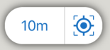
The blue-dot device marker indicates the device location on the map. The geolocate button has a blue dot to indicate that the device marker is centered in the visible area of the map. The square brackets indicate that, in centered mode, when the device moves, the device marker tracks to the edge of the visible map and then the device marker is automatically centered again to keep it visible. |
|
|
|
The device marker has changed to an arrow that tracks a moving device on the map and shows the direction it is moving. The geolocate button shows that the device is in centered mode. The square brackets indicate that when the device reaches the edge of the visible map, the map will automatically center the device on the map again. 10m indicates that the device location is accurate to within 10 meters. |
|
|
|
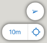
The device marker is an arrow that tracks the moving device on the map. The device arrow shows the direction of movement. The geolocate button shows that it is active but not centered or in flashlight mode. There are no brackets, so if the device moves beyond the visible part of the map, the device marker will no longer be visible. The compass arrow shows the direction of movement. 10m indicates that the location is accurate to within 10 meters. |
|
|
|
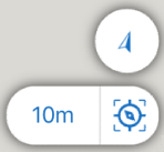
The device marker is in flashlight mode to indicate the device is rotated. The 'beam' indicates the direction that the device is pointing. The geolocate button shows it's in flashlight mode. The compass arrow shows the direction of movement. In flashlight mode, the map pans continually to ensure that the device flashlight is kept at the center of the map no matter where the device moves. To re-orient the map so that due north is again at the top of the device, click the compass arrow. |