There are two (2) types of single page prints available: Standard and Infinite.
▪Standard - Generates a single-page print based on the defined print area.
▪ Define Print Area dialog box - Launches with a standard print.
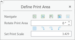
▪Navigate
▪Move print area to current extent - The defined print area is moved to the current map view and centered both horizontally and vertically.
▪Zoom to print area - Pans and zooms the map so that the defined print area is comfortably centered.
▪Pan to print area - Pans the map so that the defined print area is comfortably centered.
▪Previous extent - Toggles backwards through the list of previous map extents.
▪Next extent - Toggles forward through the list of previous map extents.
▪Rotate Print Area - Rotates the print area. Positive numbers rotate counterclockwise while negative numbers rotate clockwise. Fractions of a degree can be used, but using the up and down arrows increments by a value of 1.
▪Match area rotation to grid - Rotates the print area to match the grid.
▪Rotate 90º clockwise - Print area is rotated 90 degrees clockwise.
▪Rotate 180º - Print area is rotated 180 degrees.
▪Rotate 90º counter clockwise - Print area is rotated 90 degrees counterclockwise.
Any print area rotation results in the rotation of the print perspective, but to maintain readability, map labels will not.
▪Set Print Scale - Sets the level of zoom for the map printout. See scale.
▪Infinite - Generates a single-page print based on map selection using geometry.
▪ Infinite Print dialog box - Launches with an infinite print.
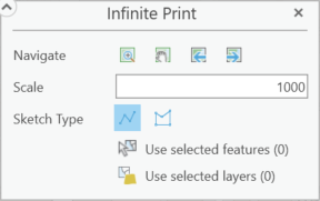
▪Navigate
▪Zoom to print area - Pans and zooms the map so that the defined print area is comfortably centered.
▪Pan to print area - Pans the map so that the defined print area is comfortably centered.
▪Previous extent - Toggles backwards through the list of previous map extents.
▪Next extent - Toggles forward through the list of previous map extents.
▪Scale - Sets the level of zoom for the map printout. See scale.
▪Sketch Type - This denotes the method used to determine the print area. For an infinite print, this is determined by either a multi-segmented line ![]() or a polygon
or a polygon ![]() . To finish building the shape, the last point selected should be a double click.
. To finish building the shape, the last point selected should be a double click.
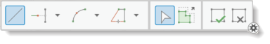
▪Drawing Tool - This tool only shows when performing an Infinite print or a Line print. The print area is defined by the drawn shapes on the map.
▪Use selected features - Select features in the map to use this function.
▪Use selected layers - Select layers in Contents pane to use this function.