This tool can be used to create annotations that are dependent on another feature. Single or batch annotations can be created as desired based on the Single or Multiple selection in this dialog.
There are two kinds of annotation that can be in a geodatabase: standard annotation and feature-linked annotation. See Esri's documentation for more details.
In the parameterization, a feature can be related to one or more annotations. The concrete annotation text is defined via an expression. I.e., the text is composed of different fields of the feature. When changes are made, the texts are automatically adjusted. If the feature is deleted, the annotation is removed as well. A detailed description on how to use this functionality can be found in the ArcGIS Pro documentation.
For single labeling, first select the feature to be labeled, e.g., a line in the map. If several label types have been parameterized and these are also included and visible in the map, they are made available for selection in a subsequent dialog. The label is automatically aligned with the line segment on which the selection was made. It is displayed as a mouse pointer feedback. The context menu can be used to rotate the orientation of the text by 180°. The generation is completed with the positioning of the text. If fast capture was activated via the context menu, the text can be placed multiple times.
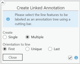
Batch labeling allows multiple parallel line features to be labeled simultaneously. The lines to be labeled are selected by entering a section bar over the lines to be included. The orientation of the labeling stack results from the direction of the section bar. The position of a label in the stack results from the position of the lines to each other. The label stack is displayed as a mouse pointer feedback. The generation is completed with the positioning of the text.
Usually, in stack labeling, all texts are aligned to the corresponding line. In the event that the various lines are not parallel, this can lead to unsightly labels. For such cases, it is possible to align all labels to the first or last line.
