Measurement
The viewer includes default configuration for displaying measurements in the viewer. Whenever users create drawings on the map, the measurement configuration is used to display the measurement lines and text. The Measurement page in Manager allows you to modify the configuration used.
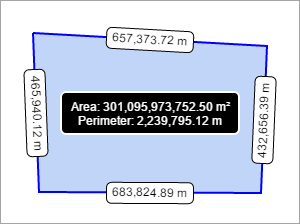
Example of a polygon's area and line measurements
Open the Measurement Page
To open an HTML5 viewer's Measurement page in Manager:
-
In
 beside the viewer.
 -
In Manager's side panel, click Measurement.
Measurement Settings
You can configure the appearance of measurement lines. For area measurements, these settings apply to the polygon's line segments. There are also two settings that apply to all measurements, Markup Layer Name and Add Markup to Map By Default.
-
Markup Layer Name: The name of the markup layer that the viewer creates for measurement markup. The default value is
Drawings.The markup layer does not appear in the layer list. The Markup Layer Name is how Essentials references drawings in the viewer. Generally, there is no reason to change this setting.
-
Line Color: The line color for markup objects, in hexadecimal format. The default value is
#0000FF. -
Fill Color: The fill color for markup objects, in hexadecimal format. The default value is
#6495ED. -
Text Color: The color of the line measurement text, in hexadecimal format. The default value is
#000000. -
Highlight Color: The color behind the text on line measurements, in hexadecimal format. The default valuse is
#FFFFFF. -
Outline Color: The color of the of the border around the text on line measurements, in hexadecimal format. The default valuse is
#000000. -
Outline Width: The width of the border around the highlighted text on line measurements, in pixels. The default value is
1. -
Highlight Radius: The border radius of the highlighted line measurement text, in pixels. The default value is
5.If the highlight radius is set to
0, the highlighted border is square. Higher values, like5or10, determine how round the border is. -
Text Size: The size of the text used for line measurements, in pixels. The default value is
12. -
Add Markup to Map By Default: Select this checkbox to add markup to the map by default. This means that when users finish drawing and move on to another activity in the viewer, their drawings remain on the map. This checkbox is selected by default.
Total Measurement Settings
You can configure the appearance of measurement totals for polygons, such as the area and the total perimeter measurement. Total measurements are displayed on top of the drawing. The settings for total measurements are:
-
Total Measurement Text Color: The color of text for the area measurements, in hexadecimal format. The default value is
#FFFFFF. -
Total Measurement Highlight Color: The color behind the text on area measurements, in hexadecimal format. The default value is
#000000. -
Total Measurement Outline Color: The color of the border around area measurements, in hexadecimal format. The default value is
#FFFFFF. -
Total Measurement Outline Width: The width of the border around area measurements, in pixels. The default value is
2.
See also...