Description
The Show Results activity displays the specified features in the application's results list or table.
In VertiGIS Studio Web, the Show Results activity ends the workflow. Any activities that follow it will not run, and no errors will be logged.
Inputs
Features |
Required Type: esri.Graphic (3.x, 4.x)* | esri.FeatureSet (3.x, 4.x)* | esri.Graphic[] (3.x, 4.x)* The feature set to display. |
FeatureSet Display Name |
Optional Type: String The display name of this feature set. If not specified the display name will be inherited from the associated layer, unless the feature set already has it defined. |
FeatureSet Id |
Optional Type: String Id of this feature set. |
Map Service Id |
Optional Id of the Geocortex Map Service this feature set is related to. In Studio Web and Studio Mobile, this refers to an Esri map service. |
Layer Id |
Optional Id of the Geocortex layer this feature set is related to. In Studio Web and Studio Mobile, this refers to an Esri layer. |
Layer Name |
Optional Type: String The name of the layer this feature set is related to. If a Layer Id is also supplied the Id will be preferred. |
Collection Name |
Optional Type: String If a name is provided, the feature set will be added to the named collection, otherwise the default collection will be used. |
Combine Mode |
Optional Type: "union" | "replace" | "intersect" | "subtract" | String How the specified features should be combined with existing features in the collection. The default is union. The Combine mode type defaults to "replace" in Studio Web. |
Label Format |
Optional Type: String If a label format is provided, the label of every feature in the feature set will be formatted based on this value. The Geocortex Viewer for HTML5 supports HTML formatting in this input. |
Description Format |
Optional Type: String If a description format is provided, the description of every feature in the feature set will be formatted based on this value. The Geocortex Viewer for HTML5 supports HTML formatting in this input. |
Long Description Format |
Optional Type: String If a long description format is provided, the long description of every feature in the feature set will be formatted based on this value. |
Icon URI |
Optional Type: String The URI of an icon to show along with the features in the feature set. |
Show Notification |
Optional Type: Boolean Whether to show a message when updating an existing collection. |
* VertiGIS Studio Workflow uses different versions of Esri's ArcGIS API for JavaScript depending on the type of host application. See Underlying Technologies for information.
Outputs
This activity has no outputs.
Properties
For information about the ID, Display Name, and Description properties, see Properties Common to all Activities.
Example
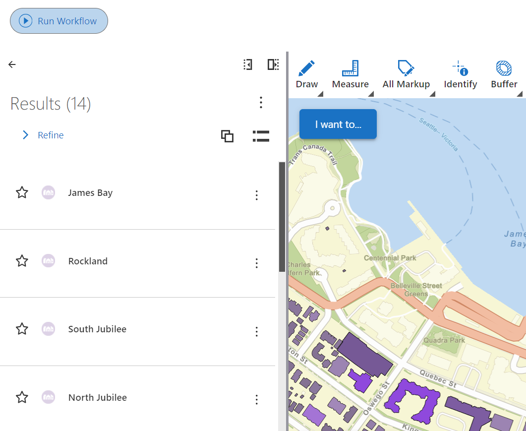
This example queries the Neighbourhoods layer and displays the matching features in the app's results list.
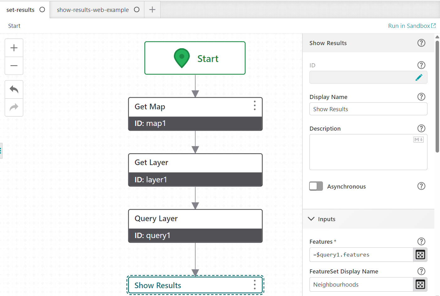
To create a workflow that incorporates show results activity, follow the steps below:
1.Add Get Map Activity after Start activity.
2.Next, add the Get Layer Activity. Set Layer Id to Neighbourhoods.
3.Add Query Layer Activity after layer1. Set Layer to: = $layer1.layer
4.Set Where to Neighbourh IS NOT NULL to exclude features with no neighbourhood name. Set Count to 20 to cap the number of features returned.
5.Enable Return Geometry.
6.Add Show Results Activity after query1. Set Features to: = $query1.features
a.Set FeatureSet Display Name to Neighbourhoods so the group is labeled clearly in the results list.
b.Set Layer Id to Neighbourhoods so the results are tied back to the correct layer.
c.Set Collection Name to searchResults to add these features to a named collection rather than the default one.
d.Set Combine Mode to replace so a repeat search replaces the previous results instead of appending to them.
e.Set Label Format to {Neighbourh} so each result in the list is labeled with the neighbourhood name.
f.Leave Show Notification disabled so the user is not prompted when the searchResults collection is updated.
When the workflow runs, up to 20 features from the Neighbourhoods layer with a non-null neighbourhood name are queried and added to the searchResults collection, replacing any features already there. Each result is labeled with the neighbourhood name and shows its address as the description.
Connectivity Requirements
This activity works when the device has intermittent connectivity to the network.
See also...