LayerCatalog Module
The LayerCatalog Module enables users to choose layers from a referenced layer catalog site. The layer catalog user interface can be used to add additional layers and map services to the map.
When a user adds a layer from a layer catalog to the map, it appears in a Layer Catalog folder in the layer list. If, in Essentials Manager, you have configured a folder where user-added layers should appear in the layer list, the Layer Catalog folder is placed within that configured folder. For more information about configuring this folder, see The Layer List.
Note that with a layer catalog, you cannot reference the same map service that is already present in the base site. Also, layer catalog layers do not support attachments, data links, instant search, and relationships.
You can configure the Layer Catalog tool to allow users to activate the Layer Catalog user interface. For toolbar configuration instructions, see Toolbar.

Layer Catalog tool
Alternatively, use the ShowLayerCatalog command to invoke the window where users can make a selection.
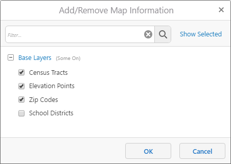
Add/Remove Map Information window
In order to access a layer catalog, your site must reference a layer catalog site unless you use an assembly provider. You can configure layer catalog sites in Geocortex Essentials Manager. For more information, see Layer Catalog Sites.
Legacy Layer Catalogs and Assembly Providers
The Legacy Layer Catalogs feature requires custom development to your Essentials installation and has been deprecated in favor of layer catalog sites. Legacy layer catalogs only work with dynamic layers.
If you wish to use an assembly provider instead of a layer catalog site, you can disable the default layerCatalogProviders property in your viewer configuration files and enable an assembly provider. Using an assembly provider requires additional Essentials configuration. See Legacy Layer Catalogs.
Configuration Properties
Module
-
layerCatalogProviders: Configure additional layer catalog providers and enable or disable them.Only one layer catalog provider should be enabled.
-
type: A provider. The default enabled provider is:geocortex.essentialsHtmlViewer.mapping.modules.layerCatalog.EssentialsSiteProviderA default assembly provider is also provided, but is disabled by default:
geocortex.essentialsHtmlViewer.mapping.modules.layerCatalog.AssemblyProvider -
enabled: Use the valuetrueto enable the configured providertypeabove.
-
-
checkboxes: Configure the checkboxes next to each folder of layers in the layer catalog.-
visibility: Configure the visibility of the checkboxes next to each folder of layers. You can configure this property toall,none, orconfiguredOnly. -
suffix: If thevisibilityproperty is set toconfiguredOnly, you can configure a suffix which folders of layers are configured with checkboxes. For example, you could configure a suffix_GROUP.
-
Views
-
LayerCatalogView: The Add/Remove Map Information window. This view allows users to select or deselect layers and map services they wish to display in the map's Layers panel.-
autoCompleteEnabled: If enabled, the filter bar suggests matching entries to the user as they enter a query into the filter bar. The default value istrue. -
minFilterLength: Sets the minimum length of characters that a filter query can be. The default value is3.
-
View Models
-
LayerCatalogViewModel:-
infoLink: An object whose properties configure an info link for all layer catalog items.This property is omitted from the default configuration files. By default, info links are not available in the layer catalog user interface.
-
enabled: Enables or disables the info link for all layer catalog items. The default value isfalse. -
command: The command to run when the user chooses a layer's info link. -
iconUri: The URI to an icon that is displayed next to an available layer in the layer catalog. The default value isResources/Images/Icons/info-12.png. -
tooltip: The tool tip to display when the info link is hovered over. -
text: The info link's text label. This property is only displayed if theiconUriis not configured.
-
-