What’s New
5.8.0 - 7 May 2025
New Capabilities:
-
Get a request header in advanced permissions. The JavaScript API available to advanced permissions now contains a
request.getHeader(name: string)function that allows you to access headers of the current request.
In most cases, the value obtained from a header cannot be trusted for security purposes. For example, you should not allow/deny access based on the User-Agent or Origin header. These values can be spoofed by the client. However, if all you need is a simple roadblock to discourage certain traffic and you understand the limitations, you can use this safely. There are cases where you could have a header attached by a network appliance that can be trusted.
The update includes these changes.
-
294111: Get a request header in advanced permissions.
-
297721: Update node to address vulnerabilities.
-
310472: Update package dependencies.
-
311466: Advanced permission expressions can no longer send web requests.
-
308175: Access Control denies applyEdits request when useGlobalIds value is "True" instead of "true".
-
290719: Monaco editor uses external JS library.
-
301283: Read-only mode Portal does not work with Access Control.
-
196983: applyEdits fails on multipart/form-data requests.
-
315062: Access token generated from Portal is invalid when VSAC is enabled.
-
This fixes a compatibility issue with ArcGIS Server 11.4.
-
5.7.0 - 28 May 2024
New Capabilities:
-
Modify request parameters with advanced permissions: The JavaScript API available to advanced permissions now contains a
request.setParameter(name: string, value: string)function that allows you to modify parameters of the current request before the request is sent to the backend ArcGIS Server.
The update includes these changes.
-
252113: Modify request in advanced permissions.
-
254840: Update Node to version 20.
-
247624: Update package dependencies to address CVE-2023-44487.
-
249774: Update package dependencies to address CVE-2023-4863.
-
255730: Log requests to
/_gxac/endpoints that target an unknown server. -
260271: Use standard typography.
-
274373: Post installer fails on German language Windows OS.
-
247434: Experimental Image Server support.
-
283525: Intermittent failure to sign in on Chrome
125.0.6422.77.
5.6.2 - 23 October 2023
The update includes these changes.
-
241075: Trial activations can fail.
-
244799: Remove invalid SaaS logic.
-
244803: Update package dependencies to address CVE-2023-4863.
5.6.1 - 23 August 2023
The update includes these changes.
-
191320: Unable to accept terms and conditions in post installer online activation.
-
237109: Error thrown inside an advanced permission
run(async () => ...)function can crash process. -
237113: Update to Node version 18.16.1.
-
237242: Update Dutch translation.
-
238034: Update help panel links.
5.6.0 - 15 May 2023
New Capabilities:
-
Compatible with ArcGIS Enterprise 11.1.
-
Access custom JSON configuration files in Advanced Permissions: The JavaScript API available to advanced permissions now contains a
getConfig(path: string)function that allows you to read.jsonfiles in the[DATA]/config/access-control/custom/directory. This pattern allows you to store configuration for your advanced permissions outside of the JavaScript source defining the advanced permissions. See example usage.
The update also includes these changes.
-
162118: Improve logging describing that geometry filters are only supported for services published by ArcGIS Pro.
-
162400: Document that geometry filters require a Geometry Service.
-
197163: Permissions not applied to services with unicode characters in the service name.
-
198634: Update Dutch translation.
-
199801: Update German translation.
-
203084: Attribute filters that include special characters like accents or umlauts break feature editing.
-
204298: Update to Node version 16.19.1 to address CVE-2022-43548.
-
230910: Update license agreement.
-
231888: Document how to configure designer access to non-federated ArcGIS servers. Learn more.
-
231920: Advanced permissions not applied correctly to edit operations from ArcGIS Pro.
-
232360: Post installer does not recognize ArcGIS Enterprise 11.1 WebAdaptor.
-
233124: Add more advanced permissions examples to documentation. Learn more.
5.5.1 - 7 November 2022
The update includes these changes.
-
186474:
multipart/form-datarequests toapplyEditsendpoint fail. -
190593: Intermittent request failures on ArcGIS Enterprise 10.9+ due to TLS 1.3 connectivity.
-
190672: Update sign-in page.
-
191060: Update package dependencies.
-
191261: Unable to load certain tiled imagery services in ArcGIS Pro.
-
194798: Avoid unnecessary logging when there are no permissions on a service.
-
195130: Update legal and privacy links.
5.5.0 - 4 July 2022
New Capabilities:
-
Enable/disable service permissions: It is now possible to temporarily disable (and then re-enable) permissions from individual services via the action menu of the service. Previously you were able to remove permissions, but there was no convenient way to restore them. This new capability saves you time and effort.
-
Time-to-live enabled cache in Advanced Permissions: The JavaScript API available to advanced permissions now contains
getCachedData(key: string)andsetCachedData(key: string, value: any, ttl: number)functions that allow you to cache and retrieve values in your scripts that may be slow to compute. This pattern can result in significant performance improvements.
The update also includes these changes.
-
181720: Update Node to version 16.
-
187399: Document more advanced permission usage examples.
5.4.0 - 25 April 2022
The product has been renamed to VertiGIS Studio Access Control throughout the designer, installer, and documentation.
The update includes these changes.
-
161607: Unable to manage permissions in environments that strip the Accept-Encoding request header.
-
164015/166154: Post installer fails if the file system root of the selected IIS website is the root of a volume like D:\.
-
181237: uploadPart requests fail.
5.3.1 - 19 July 2021
The update includes these changes.
-
39156: Add Attachment operations do not apply correct permissions in certain cases.
-
43212: Add X-Content-Type-Options header to all designer responses.
-
45898: Permissions list does not alway update after configuring field permissions.
-
45970: Permissions menus at the root level of a service should be disabled when there are no permissions.
-
46494: Support Azure Load Balancer deployments.
-
46516: Apply Edits operations require case sensitive feature ID field when attribute or geometry filters are applied.
-
46518: Support action menus to view permissions on standalone ArcGIS servers.
-
46519: Intermittent failure to open a server on first click.
-
46756: Apply SameSite=Strict to settings cookie.
-
46780: Role selector performs invalid React state update.
-
46781: Post installer is unable to sign in to ArcGIS Online.
5.3.0 - 21 June 2021
New Capabilities:
-
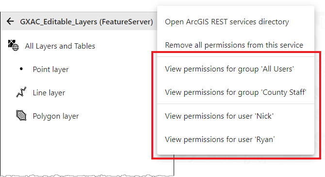
Improved visibility of permissions: The action menus of services now show you a list of all the users and groups that have permissions on the currently selected service. With a single click you then see those permissions highlighted. This feature is currently only available for federated ArcGIS Servers. Support for standalone ArcGIS Servers is coming soon.
The update includes these changes.
-
45781: Post installer does not correctly discover the backend portal URL for certain deployments with Integrated Windows Authentication.
-
45800: The menu items to remove permissions should be disabled when there are no permissions.
-
46418: Unable to apply edits to a feature service when the request includes
useGlobalIds=true. -
46423: Unable to use a UNC path in the
APP_DATA_PATHenvironment variable. -
46468: Update Dutch language strings.
-
46469: Update German language strings.
5.2.7 - 15 April 2021
The update includes these changes.
-
44800: Invalid Token 498 errors masked as 403 for standalone ArcGIS Servers.
-
45501: FeatureServer/query HTML page does not load.
-
45656: Update German language strings.
-
45657: Update Dutch language strings.
-
45661: Malformed language string on Access Permission dialog in Dutch translation.
-
45687: Duplicate language string on save/discard/cancel dialog in Dutch translation.
5.2.6 - 18 March 2021
The update includes these changes.
-
45295: Support for ArcGIS Collector.
5.2.5 - 25 February 2021
The update includes these changes.
-
42766: Improve wording in Post Installer for remote Designer URL or host name.
-
44789: Improve error messages when Designer is not able to select a server.
5.2.4 - 9 February 2021
The update includes these changes.
-
39200: Unable to sign in to ArcGIS Online or Portal in the post installer when logged in as a Windows account from a different domain.
-
44089: Update License Assistant to version 1.0.3.
-
44567: Designer fails to load when the URL does not end in a trailing slash.
-
44641: Advanced permissions should provide access to POST parameters of the current request.
-
44735: Invalid Token 498 errors are returned as 403 errors.
5.2.3 - 25 January 2021
The update includes these changes.
-
44344: Post install displays a blank screen when ArcGIS Portal has an invalid certificate.
5.2.2 - 18 November 2020
The update includes these changes.
-
38425: Post install unable to detect portal with federated ArcGIS Server version 10.5.1.
-
43138: Unable to save some renamed geometries due to name conflict.
-
43408: Geometry filtering appears disabled for existing hosted feature services following ArcGIS Server 10.8 upgrade.
-
43410: Disable Integrated Windows Authentication user and group search by default.
-
43557: Post install unable to detect portal with federated ArcGIS Server when
tokenServicesUrlis blank. -
43691: Avoid project operation between equivalent Web Mercator spatial references.
-
43754: Update License Assistant to version 1.0.2.
5.2.1 - 26 October 2020
New Capabilities:
-
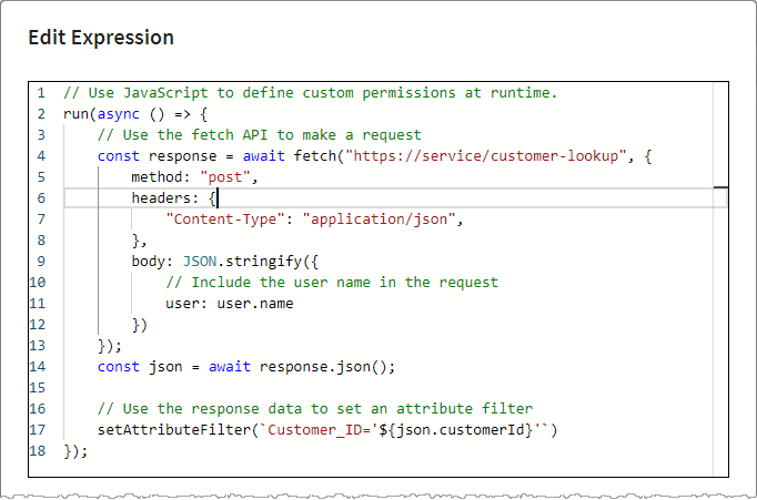
Fetch API in Advanced Permissions: Advanced permissions now provide access to the Fetch API. Fetch allows you to perform HTTP requests. This means it is now possible for the JavaScript you write in advanced permissions to call out to external web services to obtain metadata and other information about the current user that can then be used to dynamically build the right attribute filters, geometry filters and access rules for the user.
The update includes these changes.
-
40149: Include License Assistant.
-
42650: German translation updates.
-
42736: Improve confirmation dialog when deleting geometries.
-
42922: Request path logging should be at debug level.
-
42923: Dutch translation updates.
-
42924: Invalid JSON geometry error when geometry filter excludes all features from a hosted feature service query.
-
43185: Unable to create replicas based on existing portal defined map areas.
5.2.0 - 21 September 2020
New Capabilities:
-
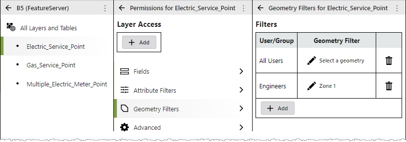
Geometry Filtering: You can now configure geometry-based permissions that let you specify which geographic data your users can see in your GIS applications. For details, see Configure Geometry Filters. ArcGIS Server 10.8+ is required for this capability.
-
Deployments without an ArcGIS Web Adaptor: You can now deploy VertiGIS Studio Access Control to environments that do not include an ArcGIS Web Adaptor. For details, see Reverse Proxy and/or Load Balancer Deployments.
The update includes these changes.
-
37132: Cursor jumps to the end when editing text boxes in the Post Installer.
-
40662: Advanced permissions are not correctly applied through related record queries.
-
40666: The
isUserInRolemethod of advanced permissions should not be case sensitive. -
40886: Dutch translation updates.
-
40887: German translation updates.
-
40921: Post installer fails to discover ArcGIS Web Adaptor if the server's DNS entry is not available.
-
41104: Field permissions not correctly applied to queries that use
groupByFieldsForStatistics. -
41882: Cookie missing on 304 cached responses for the designer application.
-
42362: Advanced permissions editor displays incorrect type information on
layer.fields.
5.1.3 - 25 May 2020
The update includes these changes.
-
37132: Cursor jumps to the end when editing text boxes in the Post Installer.
-
38927: Incorrect handling of certain field edit permissions.
-
39187: Improve handling of related record queries.
-
39849: Unable to manage services having the same name as an unsupported service type.
-
40130: Improve handling of update features requests.
-
40248: Add referrer to request object in advanced permissions.
-
40249: Prevent Ctrl + S hot key when a modal dialog is active in the Designer.
5.1.2 - 19 May 2020
The update includes these changes.
-
40410: Update license agreement.
5.1.1 - 11 May 2020
New Capabilities:
-
Dutch Translation: The Access Control Designer now includes a complete Dutch translation. Translations load automatically based on the language preferences of your web browser.
The update also includes these changes:
-
38939: Improve find endpoint support.
-
39823: Code editor provides code completion and highlighting for ArcGIS Enterprise role IDs.
-
39928: Update Designer sign-in page.
-
39861: Include additional German language strings.
-
39931: Intermittent "resource busy or locked" error in post installer.
-
40241: POST requests to secured endpoints can fail when the content-type header contains a character encoding.
-
40275: Large POST requests can fail with HTTP 413 "request entity too large" error.
5.1 - 20 April 2020
New Capabilities:
-
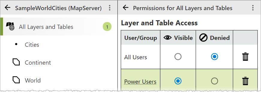
Service Permissions: You can now apply permissions to the top level of a service. This helps simplify many advanced scenarios.
For example, you can deny feature editing for a group of users at the service level, but allow that same group to edit specific layers of the service. This approach is often simpler than setting deny rules on every layer except those you want to allow.
-
Geoprocessing Task Permissions: You can now apply permissions to individual geoprocessing tasks within a geoprocessing service.

-
Advanced Permissions: You can now apply advanced permission rules using JavaScript.
The advanced permission editor provides a rich JavaScript editing experience that includes code completion suggestions. You can write your own business logic to examine details about the current user and the resources the user is attempting to access, then assign the exact permissions you need to protect your services, layers and data.
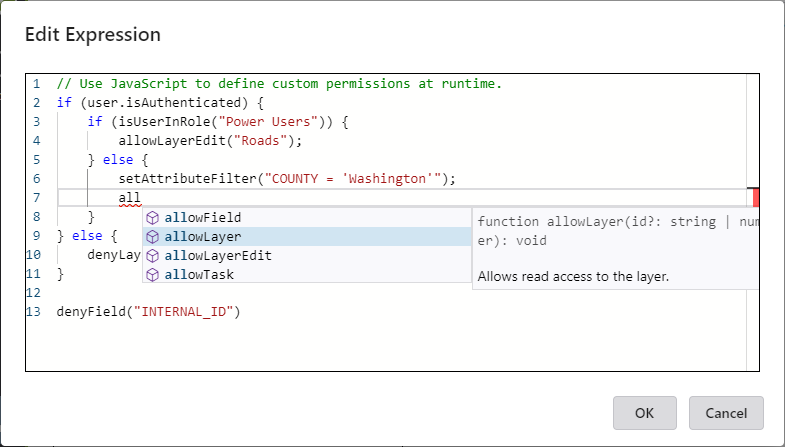
You will need a basic understanding of JavaScript to use this feature.
-
German Translation: The Access Control Designer now includes a complete German translation. Translations load automatically based on the language preferences of your web browser.
The update also includes these changes:
-
38816: Switch from an IIS hosted service to a standalone Windows service.
-
38822: Improve verbose logging and log level configuration.
-
39148: Support configuration option to disable Integrated Windows Authentication user and role lookups from Designer.
-
39189: Automatically normalize remote Designer URLs in the post installer.
-
39226: Improve rule evaluation of FeatureServer/query endpoint.
-
39412: Exclude extraneous files from the installer.
-
39544: Gateway timeout when publishing services from ArcMap or ArcGIS Pro.
-
39565: Move the Save/Discard buttons to the banner region of the Designer.
-
39590: The post installer is unable to discover web adaptors when IIS contains invalid applications.
5.0.2 - 16 March 2020
The update includes these changes:
-
37714: Improve the handling of Home and End keys in Designer's role selector.
-
38638: Improve handling of secured services.
-
38820: Provide consistent JSON responses for denied endpoints.
-
38826: Improve handling of multiple attribute filters.
-
38828: Relationships to denied layers should be excluded from layer schema responses.
-
38843: Unable to complete online activation in the Post Installer when the logged in Windows account is different from the Windows account used to complete the ArcGIS Online sign-in.
-
38906: Support online trial activations in the Post Installer.
-
38915: Improve wording in Post Installer.
-
38985: Duplicate window opens when clicking hyperlink in the Post Installer.
-
38991: Hide tooltips that show the internal IDs of built-in roles in Designer.
5.0.1 - 24 February 2020
The update includes these changes:
-
35393: Keyboard navigation on service detail panel of Designer requires an extra tab in Firefox.
-
37518: Incorrect role lookup when using token security.
-
38368: Duplicate attribute filters should not be added to requests.
-
38534: Support online license activation in the post installation application.
-
38653: Synchronizing replicas can fail for protected layers.
-
38678: Unable to add certain layers to the Portal map viewer when permissions configured within the same service.
-
38692: Improve token validation performance.
5.0 - 4 February 2020
Version 5.0 is the initial release of VertiGIS Studio Access Control. The following features and capabilities are included in this initial offering.
Applying Permissions
VertiGIS Studio Access Control allows administrators to configure permissions that control who can view and edit the layers and fields in ArcGIS Server services.
Permissions are configured in the Access Control Designer, and you can use them to control both user and group access.
Sign in to the Access Control Designer using your ArcGIS Administrator identity. If you do not have an on-premise portal, you can sign in with your ArcGIS Online account and manage your on-premise services.
Applying Attribute Filters
The Access Control Designer also provides attribute filters that let you specify exactly which features users can see in your GIS applications.
Attribute filters are constructed using a Structured Query Language (SQL) expression (WHERE clause) that selects features or table records that match the selection criteria.