LayerAddition Module
The LayerAddition Module allows end users to search for layers and map services that have been configured as service connections within Geocortex Essentials Manager.The ability of users to search service connections must be enabled in Manager. For instructions, see Allow End Users to Search a Service Connection.
To allow users to add layers and services from configured service connections, you can configure the Add Layers tool to the viewer toolbar. For more information about configuring toolbar items, see Toolbar.

Add Layers tool
Alternatively, you can activate the Add Layers user interface with the AddMapLayerInteractive command.
Add Layers User Interface
When the Add Layers function is activated, the Add Layers user interface appears in the viewer's main panel. Adding layers and map services is a three step process.
To add a layer or map service to the layer list:
-
Click the Add Layers tool in the toolbar to activate the Add Layers user interface.
-
Enter a search term or the URL of a known map service and press the Search button.
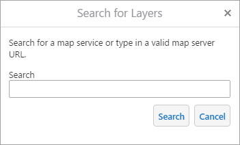
Search for Layers dialog box
-
Select a configured service connection.
The number of relevant search results for each connection is displayed in parentheses next to the service connection's name. For example, "ArcGIS Online (20)". If a service connection returned no results for the search term, the service connection does not appear in this list.
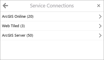
Search Connections dialog box
-
Select a result from the list of available map services.
-
Use the
 Add button next to a map service or layer to add it to the Layer List.
 -
Select a result to see a list of available layers that you can add.
The number of available layers is displayed next to the service's name. For example, "Wells (Feature Service) (6)".
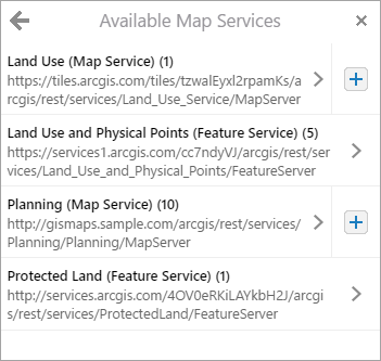
Available Map Services dialog box
The Add Layers user interface closes.
The user-added layer appears at the top of the layer list, unless you have specified that user-added layers should appear within a configured folder. For more information, see The Layer List.
-
If you use Add Layers to add a WFS layer in the viewer, query and search operations are not supported for that layer. Selecting the enable checkboxes for query and search in the layer properties panel has no effect.
User-Added Layer Actions
You can configure the ![]() Action Menu associated with layers and user-added layers in Manager or in the viewer configuration files. With the viewer's default configuration, the Action Menu for user-added layers includes the Edit Layer Properties action, the Remove Layer action, and all of your other configured layer actions. Only dynamically added layers can access the Edit Layer Properties and Remove Layer actions. For more information about menu configuration, see Context Menus and Menu Module.
Action Menu associated with layers and user-added layers in Manager or in the viewer configuration files. With the viewer's default configuration, the Action Menu for user-added layers includes the Edit Layer Properties action, the Remove Layer action, and all of your other configured layer actions. Only dynamically added layers can access the Edit Layer Properties and Remove Layer actions. For more information about menu configuration, see Context Menus and Menu Module.
When the user selects the ![]() Action Menu button next to a user-added layer, they can select the Edit Layer Properties action if it is configured. This action allows users to change the way that the user-added-layer behaves in the viewer. The following configuration settings are available:
Action Menu button next to a user-added layer, they can select the Edit Layer Properties action if it is configured. This action allows users to change the way that the user-added-layer behaves in the viewer. The following configuration settings are available:
-
Name: The name of the user-added layer in the Layer List.
-
Identify enabled: When this checkbox is selected, identify operations include results from the user-added layer that is being configured.
-
Search enabled: When this checkbox is selected, search operations include results from the user-added layer that is being configured.
-
Query enabled: When this checkbox is selected, query operations included results from the user-added layer that is being configured.
-
Show map tips: When this checkbox is selected, map tips appear when the user-added layer's features are selected.
Group layers are not searchable or identifiable. As a result, group layers do not include the Identify enabled, Search enabled, or Query enabled checkboxes in the Edit Layer Properties dialog box.
User-Added Map Service Actions
You can configure the ![]() Action Menu associated with user-added map services in Manager or in the viewer configuration files. By default, the only configured menu item is the Remove Service action, which removes the user-added map services from the Layer List. Only dynamically added map services can access the Remove Service action. For more information about menu configuration, see Context Menus and Menu Module.
Action Menu associated with user-added map services in Manager or in the viewer configuration files. By default, the only configured menu item is the Remove Service action, which removes the user-added map services from the Layer List. Only dynamically added map services can access the Remove Service action. For more information about menu configuration, see Context Menus and Menu Module.
Configuration Properties
Module
No configuration properties
Views
-
AddLayerDialogView: Noconfigurationproperties -
ServiceConnectionsDialogView: Noconfigurationproperties -
MapServicesDialogView: Noconfigurationproperties -
SubLayersDialogView: Noconfigurationproperties -
LayerPropertiesView: Noconfigurationproperties
View Models
-
LayerAdditionViewModel:-
zoomToUserAddedLayers: When a layer is added, the map zooms to its full extent. The default value istrue. -
layerDefaults:-
searchable: Allows user-added layers to participate in Global Search. The default value istrue. -
identifiable: Allows user-added layers to be used with identify operations. The default value istrue. -
queryable: Allows user-added layers to be used with the Query Builder. The default value istrue. -
showMapTips: Displays map tips for all user-added layers. The default value istrue.
-
-
whitelistPortalResults: If you want to disallow users from adding public layers from Portal for ArcGIS, set tofalse; otherwise, set totrueor omit this property. This property is omitted by default. -
whitelistAgolResults: If you want to disallow users from adding public layers from ArcGIS Online, set tofalse; otherwise, set totrueor omit this property. This property is omitted by default.
-
-
LayerPropertiesViewModel: Noconfigurationproperties.