The Search component allows your user to find spatial data and locations on the map. When they click on a search result, the map zooms to that location.
You can configure the maximum number of search results to display from each feature source (for example, layer, sublayer, table, geocoder), and the number of suggestions to display based on the user's input. To include a specific layer in the search, enable the Included option in Layer List > Layer Extensions).
The search results come from one of the following:
•The Geocoder service. If the Geocoder Enabled option is disabled, the user can search for data only.
•Standard Esri search.
Your user can click Settings in the Search bar to access the Search Options.
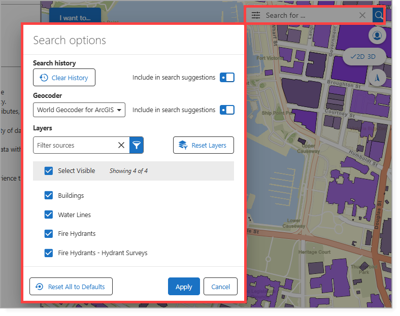
The Search Options are described in the table below.
Setting |
Description |
|---|---|
Clear history |
Removes all previously saved search terms from the user's local search history. |
Geocoder |
Defines the service used to find and locate addresses, places, or coordinates on the map. |
Include in search suggestions |
When enabled, results from the selected Geocoder are included in the search suggestions. |
Layers |
Filters the layers to include in the search. |
Reset Layers |
Removes all previously entered layer filter data. |
Select Visible |
Includes the user-selected layers in the search. |
Reset All to Defaults |
Clears all Search Option settings to the default configuration. |
Main Settings
Field |
Description |
|---|---|
Title |
The heading to display for the component. The title appears in both Web and Web Designer. |
Icon |
The symbol used to represent the component. |
Maximum Results |
Type in the maximum number of search results to display on a single page. The default is set to 50. |
Maximum Search Suggestions |
Type in the maximum number of search suggestions to offer a user. The default is 6. |
Geocoder Enabled |
Whether to use the geocoder as part of the search results. The default is true. |
Events
Field |
Description |
|---|---|
Search Cleared |
The command to run when the user clears the search box. A command is an action the app should perform. Some commands have additional settings you can configure. |
Search |
The command to run when the user performs a search. A command is an action the app should perform. Some commands have additional settings you can configure. |
Visibility Filters
Field |
Description |
|---|---|
Visible To |
Determines which users and groups can access this component. If no users or groups are specified, all users can access this component by default. The Hidden From setting overrides this setting. |
Hidden From |
Determines which users and groups are explicitly forbidden to access this component. This setting overrides the Visible To setting. |
Layout
Field |
Description |
|---|---|
Slot |
Select the slot to position the component within the Map component. In addition to the various positions on the map, such as Top Left and Bottom Center, you can position the component within the map context menu, which appears when the user right-clicks the map. You can also position the component within the Popup slot, which appears at the mouse cursor. This setting only appears when the component is within the Map component. |
Margin (px) |
The margin space around the component, measured in pixels. |
Initially Hidden |
Specifies whether or not the component is initially hidden when the app loads. If selected, the component remains hidden unless activated, for example, by the Show command. |
Map |
The Map components this component affects. This setting cannot be modified if this component is either a subcomponent of a Map component or there is only a single Map component in the app. |