ArcGIS Server Layers
ArcGIS Server Feature Layers
A feature layer is a special type of graphics layer that automatically retrieves data from an ArcGIS Server layer and then renders the geometry on the client.
Feature layers support rich client-side functionality, such as dynamic re-symbolization, charts, clustering, heat maps, and client-side editing that can be applied back to the server.
Essentials supports feature layers from ArcGIS Server feature services and ArcGIS Server map services.
-
Feature Layer from Feature Service:
-
Layers from feature services must be added to the map as feature layers.
-
You can only add one layer from a feature service at a time. To add multiple feature layers from a feature service, add them one at a time.
-
Feature layers from feature services can support the full range of client-side functionality, including client-side editing.
-
-
Feature Layer from Map Service:
-
Layers from map services can be added to the map as feature layers, or as map services.
-
You can only add one layer from a map service as a feature layer at one time.
-
Feature layers from map services can support all the client-side functionality except editing.
-
For instructions on adding feature layers to the map, see Add Services to the Map.
Edit a Feature Layer
On the Map Services tab in Geocortex Essentials Manager, feature layers have two parts:
-
Service Component: The service component of a feature layer allows you to configure service settings, such as connection settings, and service-level features, such as clustering and heat maps.
-
Layer Component: The layer component of a feature layer allows you to configure layer settings, such as the information to display in feature descriptions, and layer-level features such as charts, reports, and data links.
The service component does not appear on the Layer List tab. This makes the feature layer appear as a single item in a viewer's Layer List.
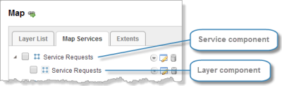
Feature layer shown on the Map Services tab on Manager's Map page
To edit the service component of a feature layer:
-
In
-
Click Edit MapService
 beside the service component of the feature layer you want to edit.
To edit the layer component of a feature layer:
-
In
You can also edit the layer component on the Layer List tab, if the feature layer is in the Layer List.
-
Click Edit Layer
beside the layer component of the feature layer you want to edit.
See also...
ArcGIS Server Time-Aware Layers
ArcGIS Server time-aware layers store information about how the layer's dataset changes over time. You can add ArcGIS Server stream layers to a site's map. See Add Services to the Map.
You can configure a time slider that end users use to visualize time-aware data in the viewer. The time slider shows and hides features based on each feature's time data and the user's time selection on the timeline.
See also...
ArcGIS Server Stream Layers
ArcGIS Server stream layers provide real-time data from ArcGIS GeoEvent Extension for Server using HTML5 WebSocket technology. You can add ArcGIS Server stream layers to a site's map. See Add Services to the Map.
To work with stream layers in the Geocortex Viewer for HTML5, the browser must support this technology.
ArcGIS Server Dynamic Layers-Enabled Services
ArcGIS Server's Dynamic Layers feature enables other applications to change the appearance and behavior of the layers in the map service. Geocortex Essentials supports the Dynamic Layers feature.
See also...
ArcGIS Server Image Services
ArcGIS Server image services serve raster and mosaic images that are pre-rendered on the server. You can add ArcGIS Server image services to a site's map. See Add Services to the Map.
In Essentials, image services have a map service component, but no layer component. This means that you can configure map service settings for an image service, but there are no layer settings.
You can configure an image service to allow identify operations. Essentials does not support any other type of query besides identify on image services.
See also...
Identify Operations on Image Services
ArcGIS Server Raster Layers
You can add ArcGIS Server raster layers to a site's map, either by adding the map service that the raster layer belongs to, or by adding the raster layer alone.
See also...
Identify Operations on Raster Layers
ArcGIS Vector Tile Layers
ArcGIS vector tile layers are similar to image layers, except they store a vector representation of the data.
The following do not support vector tile layers:
- Geocortex Mobile App Framework
- Geocortex Essentials Printing
Vector tile layers can display in newer browsers only. To add a vector tile layer to a site's map, you must run Manager in a current browser such as the current version of Chrome, Firefox, Edge or Internet Explorer. Similarly, end users must run a current browser to be able to see vector tile layers in the viewer.
Vector tile layers are hosted in ArcGIS Online or Portal for ArcGIS. To add a vector tile layer to the map, you can either specify the layer's URL or you can search for the layer. See Add Services to the Map.
For more information about vector tile layers, see the ArcGIS article Vector Tile Layers.